

STORIES, EARTH SHAKING, LEARNING, TEACHING
How do stories of cataclysmic events help inform students about geosciences and cultures?
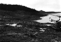
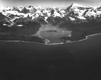
I was 21 years old, living in Haines. I traveled to Sitka to be a working artist and chaperone for the Sitka Fine Arts Camp. There I met a young girl attending camp who told me her name was Edri. I told her that was a pretty name, where did she get a name like that? She said she was named after a boat. I laughed and said, “You mean, the boat was named after you?” as usually boats are named after women. She looked at me soberly and said, “No, I was named after my dad’s boat the Edri. I was born right after he lived through the great wave at Lituya Bay.”http://www.amazon.com/Land-Ocean-Mists-Coast-Glacier/dp/1577853490/ref=sr_1_1?ie=UTF8&s=books&qid=1266787232&sr=1-1#reader_1577853490
Not too many years later I moved to Glacier Bay and became a Park Naturalist aboard boats in the bay. I read The Land and the Silence by Dave Bohn and later Land of the Ocean Mists: The Wild Ocean Coast West of Glacier Bay by Francis E. Caldwell, edited by Robert N. DeArmond.
All of S.E. Alaska is made of fault lines, with one of the most impressive areas the “suture zone” in Johns Hopkins Inlet in NW Glacier Bay. Red Rock there has been matched to rock on Prince of Wales Islands far to the south. Rock and land that has been seared off in the northern course of the Pacific plate literally picking up land as it twists slightly to the west on its northern course and re-deposits the land farther north. You can see it from the sky, and from Google Earth. http://www.usc.edu/dept/tsunamis/alaska/1958/webpages/lituyacloseup.html
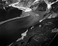
LITUYA BAY, OUTER COAST, ALASKA
Even today, I hear or feel earthquakes in Glacier Bay, up towards Haines, near Lituya Bay, and off the outer coast where the plates meet. During a two-year period in Sitka during 1988-1990, I jumped up many nights to the tsunami warnings, put my small children on their bikes, then we headed up towards the high point of town, the high school, until the all-clear.
Moving to Gustavus in 1977, I met a woman who was 5 in 1964 in Anchorage, as the earth opened in her yard and swallowed her little brother before her eyes. She could not hold onto him. She has had emotional problems all her life. Another friend lost his incredible hand-built just-finished fishing boat which went far out to sea as the tide stretched unfathomably low in Valdez, then raced in to chase all inhabitants up the road away from the beach, leaving his boat sunken and demolished.
In the 1990s my mother ended up in the hospital with pleurisy in Anchorage due to the ash fall from Mt. Redoubt leaving a grey landscape covering her Wasilla home.
Curiously, people tend to immediately repopulate areas where volcano, earthquake and tsunami destruction happens. I was in Kodiak in February, 2009, as plastic covered all library and museum shelves due to the activity of Mt. Redoubt. Photos of the ash inundation and the tsunami damage from the 1960s bring the question of why people tend to rebuild exactly where the devastation took place and could easily take place again.
Three days ago when I checked, the latest earthquakes were: 1) one at the China/Russia/N. Korea border; 2) in the Kuriles; 3) 12 each in Alaska, just north of Anchorage; 4) 22 each in California; 5) one in Bolivia; 6) one in New Zealand islands; and 7) one in Fiji. Living on the Pacific Rim is surely the testiest places on and under the earth!
How could you use Google Earth to make learning geoscience more engaging? What other resources could apply to learning about earthquakes?
All Alaskans have stories of the land in action – extreme weather, landslides, floods, loss of sea ice, loss of seacoast land, earthquakes, volcanoes. This is an easy link for students to make to connect geosciences in their homeland to the stories from their own lives in their own homeland with sense of place. I believe that Alaskan students can use their regional/local libraries and museums as well as their elders to research local historical stories of the land’s cataclysms over time and their relationship to those events. I also believe that using Google Earth will bring home to Alaskan students the crucial importance of the land’s dynamics to their past, present and future life in the area.
The dynamic land has also fostered creative expression that parallels the dependence on the land and the sea: See Inua: Spirit World of the Bering Sea Eskimo and Exhibition Catalog by Jeanne M. Barry Editor.
|
|
|
|
|
|
|
|
|
|
|
|
|
|
|
|
|
|
From Booklist
“.. the tragic conquest of a little-discussed ethnic group is filtered through an unlikely point of view. Thirty-one-year-old Brandy is a blond drifter who impulsively follows her boyfriend to a fishing port in the Aleutian Islands. Left alone during his trips at sea, she becomes obsessed with hints, from sources as unlikely as bathroom graffiti and an Aleut coke-whore, of a secret the native community would prefer remain hidden--particularly from a "very fuckin' white" cocktail waitress. The first--person narrative alternates with chapters set in catastrophic periods of Aleut history, tracing several generations of women whose grim resolve left a daunting, bloody legacy to their daughters and granddaughters: "In your hands you hold your fate, and in no one's hands but your own does your future rest." Insertions of scholarly information distract from the drama of Brandy's personal transformation, but Dyson's talent is .. balancing of tribal perspectives and those of her canny, questing protagonist. Jennifer Mattson
Copyright © American Library Association
OTHER RESOURCES:
The Dynamic Planet, interactive geoscience map available:
|
|
on GoogleEarth: |


Kate, your stories are compelling and deeply connected to place. Great links and books refs, too.
ReplyDelete