Kiksadi Bear in Sitka

Kiksadi Bear in Sitka
inua spirit in sculpture

Thursday, February 25, 2010

Oceans within, oceans surrounding


O


Occccceannnnn… Climate, culture, ocean

40 million square miles

12,200 average feet deep Mariana Trench 36,198 feet deep


Ocean ridge mountain 40,000 miles long --

the longest mountain range known in our universe

Mauna Kea rising 33,474 feet from the ocean floor to the sky

Oooccccceannnnnn…71 % of our planet’s surface

Containing 97% of our planet’s water

Holding heat near the surface Deep as 2.5 miles

Providing 99 % of earth’s living space

C


ontaining the abyss habitat With less than 10% explored by humans

Challenger Deep is one mile deeper than Mt. Everest is high.

Avg. 2 degrees C or 39 degrees F

E


xtreme water pressure of 8 tons per square inch Gulf Stream flowing 300 times faster than the

Amazon flow Containing 20 million tons of gold Blue absorbed by phytoplankton, drifting

Deep-sea hydrothermal vents along mid-ocean ridges Holding new life

Blue whale, heart larger than an automobile

Grey whale migrating across 10,000 miles of ocean each year

Great Barrier Reef, seen from the moon. Oceans threatened by oil Fisheries fishing

Overfishing Pollution cities by the sea polluted coastal waters Plastic, plastic, plastic

A


Coral reef is degrading Coral reefs declining High seas least protected treaties agreements

Protections Critical marine habitats Coral reefs, seagrass beds, mangroves

Commercial fishing, illegal fishing, by-catch destruction Coastlines 315,000 miles,

circling equator 12 times Coastal zones, half the world’s population within 60 miles of coastlines

Rising sea level 4-10 inches over past 100 years Ice melting, oceans rising

Volcanoes from the oceans 10 % of earth’s surface covered with ice

Sea levels determined by ice not melting Occcceannnnns… Containing salt

Absorbing carbon dioxide Plankton forming the base of the food web Reefs threatened

Contamination, oil, plastics, destruction Ocean planet, ocean home, distress

N


OW Ocean planet, worth protecting Appreciating Recognizing water in us

Recognizing ourselves as encapsulated oceans of salty water, environments as ourselves

In ourselves, elements of the ocean entity.


Would students be interested in taking words and phrases from facts about oceans and turning them into their own poetry, then making music from the words, or adding drum beats? Use themes of thermal energy, underwater plant life/phytoplankton; seasonal patterns; seasonal changes on earth and in the water; solar energy; sea surface; temperature; winds; currents; evaporation; water circulation; ice; Gulf Stream; water density; thermohaline conveyor; others?


Consider LATTITUDE in understanding oceans, temperatures, effects on the land where we live.

In discussing and using GOOGLE EARTH for looking around the globe, consider showing the film LONGITUDE, to show how cultures transform as elements of the ocean become understood over time.

http://ecx.images-amazon.com/images/I/519S23K6RHL._SS500_.jpg

…”Longitude combines drama, history, and science into a stimulating, painstakingly authentic account of personal triumph and joyous discovery… The first story involves the successful 40-year effort of 18th-century clockmaker John Harrison…to solve the elusive problem of measuring longitude at sea. In 1714 the British Parliament had offered a generous reward to anyone who solved the problem, and Harrison devoted his life to that solution. The second story, some 200 years later, involves the effort of shell-shocked British Navy veteran Rupert Gould (Jeremy Irons) to restore the glorious clocks that Harrison had built. Like Harrison, Gould is the most admirable type of obsessive, but, also like Harrison, he risks his marriage to accomplish his difficult task.


Thousands of sailors perished at sea before Harrison's triumph changed history, but Longitude demonstrates that Harrison's glory was slow to arrive--and his prize money even slower. A fascinating study of 18th-century British politics and clashing egos in the arena of science, the film is both epic and intimate in consequence… Rallying after sickness to prove the integrity of their marvelous seafaring chronometers, the Harrisons still had to fight for official recognition, and Gould's restoration of the Harrison clockworks provides a fitting coda to this exceptional story about the thrill of discovery and the tenacity of remarkable men. --Jeff Shannon

*********

IN MY LIFE, my father was in the Navy off of the Aleutian Islands near Adak during WWII. He was from inland in North Carolina, so this was a whole new world for him, and he loved it. Ten years after the war, he brought his family back to Juneau, S.E. Alaska. I grew up rowing and going fishing, on the water a lot around Auke Bay, Tee Harbor, Lena Cove, and northern Admiralty Island. From the age of 18, I ran a small pleasure boat myself in the same region. Then I married a boat driver, boat builder, [See sailglacierbay.com)]and have proceeded to live my life on the water: charter fishing, subsistence set netting, working as a naturalist, kayaking with guests with humpback whales, exploring the outer coast off of Yakobi, traveling between Sitka and Gustavus, weather watching, sailing..


After helping build a catamaran in Gustavus for 10 years, we launched in the Salmon River, Icy Passage. After whale watching and cruising Glacier Bay doing overnight tours, we got a contract with the US Weather Bureau out of Juneau to "ground-truth" data received from satellites reading weather of over 20 knot winds off of the water surface in a study area from Pt. Adolphus on northern Chichagof Island to Pleasant Island in Icy Strait and east towards Hoonah.

The satellite would travel overhead for about 40 minutes during predicted high winds (using light reflected off of the ocean in satellite video). During this 40 minutes, Fritz would keep the boat headed into the wind during periods of 5 minutes, during which I recorded wind data -- direction, amplitude and Beaufort Scale number -- data from our anemometer attached to our 30-foot high sail mast, reading in the wheelhouse. We read weather data in the dark, in the wind, dealing with current and tides, trusting the instruments and our faith in the boat on the water. I learned a lot. There are patterns to the wind, changes with tides and currents, and patterns of the wind on water in open ocean and closer to large (Chichagof) and small island (Pleasant Island) shores.

We rode the sea and gave data to compare that coming from the satellites. I've never before felt like a scientist, nor a native using my local knowledge to stay in control and record nature. I realize how new the satellite data is, and how native stories and knowledge must be used to understand a longer period of time, from long before the satellites circled our earth.

Now seeing the videos of native villages, oceans currents, density, patterns of water directions, I can see how scientific data can mesh with native ways of knowing. It takes close knowledge of an area to decipher knowledge gathered from the sea. (Paul Marks, "..living by the moon, by the seasons, being interdependent on the sea.") I see images for artistic representation in the themes of subsistence: images of hunting, fishing, gathering, teaching, learning, celebration always with respect and honor for the land, the sea, the animals. (TD Living from Land and Sea): salmon, bowhead whale, seals, sealions, forage fish, sandlance. Dolly Garza, Tlingit and Haida woman from Sitka, states her obligation to protect native rights. She can hunt sea mammals, and understands subsistence, consumptive and artistic uses.


Sunday, February 21, 2010

Stories, Earth Shaking, Teaching, Learning


STORIES, EARTH SHAKING, LEARNING, TEACHING

How do stories of cataclysmic events help inform students about geosciences and cultures?

I was 21 years old, living in Haines. I traveled to Sitka to be a working artist and chaperone for the Sitka Fine Arts Camp. There I met a young girl attending camp who told me her name was Edri. I told her that was a pretty name, where did she get a name like that? She said she was named after a boat. I laughed and said, “You mean, the boat was named after you?” as usually boats are named after women. She looked at me soberly and said, “No, I was named after my dad’s boat the Edri. I was born right after he lived through the great wave at Lituya Bay.”http://www.amazon.com/Land-Ocean-Mists-Coast-Glacier/dp/1577853490/ref=sr_1_1?ie=UTF8&s=books&qid=1266787232&sr=1-1#reader_1577853490

Not too many years later I moved to Glacier Bay and became a Park Naturalist aboard boats in the bay. I read The Land and the Silence by Dave Bohn and later Land of the Ocean Mists: The Wild Ocean Coast West of Glacier Bay by Francis E. Caldwell, edited by Robert N. DeArmond.


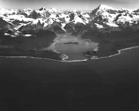
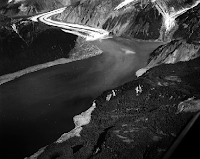
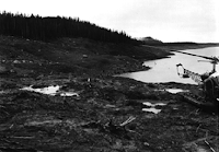
The first time I flew from Gustavus up through Glacier Bay and up to Dry Bay, then down along the coast to Lituya, in towards the east, I saw the 1500 foot scar of the 1958 wave still there in the change of vegetation, and imagined being in the bay with a giant wave approaching. Looking north from the inside of the Bay I could see Desolation Valley in its impressive expression of shifting plates moving up the fault line of the joint. Up over the eastern glaciers and mountains, then down into West Dundas Bay we flew, seeing bear after bear along the beaches.

All of S.E. Alaska is made of fault lines, with one of the most impressive areas the “suture zone” in Johns Hopkins Inlet in NW Glacier Bay. Red Rock there has been matched to rock on Prince of Wales Islands far to the south. Rock and land that has been seared off in the northern course of the Pacific plate literally picking up land as it twists slightly to the west on its northern course and re-deposits the land farther north. You can see it from the sky, and from Google Earth. http://www.usc.edu/dept/tsunamis/alaska/1958/webpages/lituyacloseup.html


LITUYA BAY, OUTER COAST, ALASKA

Even today, I hear or feel earthquakes in Glacier Bay, up towards Haines, near Lituya Bay, and off the outer coast where the plates meet. During a two-year period in Sitka during 1988-1990, I jumped up many nights to the tsunami warnings, put my small children on their bikes, then we headed up towards the high point of town, the high school, until the all-clear.

Moving to Gustavus in 1977, I met a woman who was 5 in 1964 in Anchorage, as the earth opened in her yard and swallowed her little brother before her eyes. She could not hold onto him. She has had emotional problems all her life. Another friend lost his incredible hand-built just-finished fishing boat which went far out to sea as the tide stretched unfathomably low in Valdez, then raced in to chase all inhabitants up the road away from the beach, leaving his boat sunken and demolished.

In the 1990s my mother ended up in the hospital with pleurisy in Anchorage due to the ash fall from Mt. Redoubt leaving a grey landscape covering her Wasilla home.

Curiously, people tend to immediately repopulate areas where volcano, earthquake and tsunami destruction happens. I was in Kodiak in February, 2009, as plastic covered all library and museum shelves due to the activity of Mt. Redoubt. Photos of the ash inundation and the tsunami damage from the 1960s bring the question of why people tend to rebuild exactly where the devastation took place and could easily take place again.

Three days ago when I checked, the latest earthquakes were: 1) one at the China/Russia/N. Korea border; 2) in the Kuriles; 3) 12 each in Alaska, just north of Anchorage; 4) 22 each in California; 5) one in Bolivia; 6) one in New Zealand islands; and 7) one in Fiji. Living on the Pacific Rim is surely the testiest places on and under the earth!

How could you use Google Earth to make learning geoscience more engaging? What other resources could apply to learning about earthquakes?

All Alaskans have stories of the land in action – extreme weather, landslides, floods, loss of sea ice, loss of seacoast land, earthquakes, volcanoes. This is an easy link for students to make to connect geosciences in their homeland to the stories from their own lives in their own homeland with sense of place. I believe that Alaskan students can use their regional/local libraries and museums as well as their elders to research local historical stories of the land’s cataclysms over time and their relationship to those events. I also believe that using Google Earth will bring home to Alaskan students the crucial importance of the land’s dynamics to their past, present and future life in the area.

The dynamic land has also fostered creative expression that parallels the dependence on the land and the sea: See Inua: Spirit World of the Bering Sea Eskimo and Exhibition Catalog by Jeanne M. Barry Editor.


And for a controversial look at impact/crashing convergence of cultures in the fractious landscape of the Aleutians, see: And She Was by Cindy Dyson. (definitely R rated – good for college students and community adult book clubs):


From Booklist

“.. the tragic conquest of a little-discussed ethnic group is filtered through an unlikely point of view. Thirty-one-year-old Brandy is a blond drifter who impulsively follows her boyfriend to a fishing port in the Aleutian Islands. Left alone during his trips at sea, she becomes obsessed with hints, from sources as unlikely as bathroom graffiti and an Aleut coke-whore, of a secret the native community would prefer remain hidden--particularly from a "very fuckin' white" cocktail waitress. The first--person narrative alternates with chapters set in catastrophic periods of Aleut history, tracing several generations of women whose grim resolve left a daunting, bloody legacy to their daughters and granddaughters: "In your hands you hold your fate, and in no one's hands but your own does your future rest." Insertions of scholarly information distract from the drama of Brandy's personal transformation, but Dyson's talent is .. balancing of tribal perspectives and those of her canny, questing protagonist. Jennifer Mattson
Copyright © American Library Association

OTHER RESOURCES:

The Dynamic Planet, interactive geoscience map available:


Interactive map

on GoogleEarth: